Navigating the Bar of Charleston Harbor: Gateway to the Atlantic
 Processing Request
Ship traffic flowing in and out of Charleston Harbor has played a vital role in the local economy for more than 350 years. For most of that time, however, a network of shifting sandbars at the mouth of the harbor complicated the passage of all large vessels. Early maritime trade blossomed with the aid of skilled pilots and navigational buoys and beacons, but natural silting threatened to choke commercial traffic in the late nineteenth century. Thanks to the construction of an artificial channel through two massive stone jetties, South Carolina’s principal port continues to flourish.
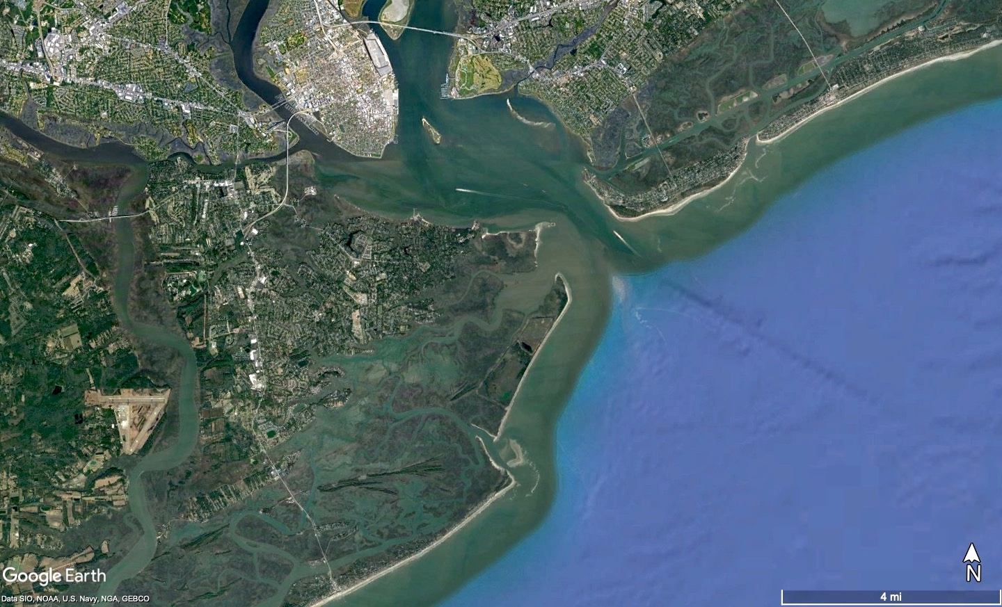
The main character of this story—the bar of Charleston Harbor—played an important role in the early development of South Carolina that is easily forgotten in the twenty-first century. It once represented a constant yet shifting, hydra-headed obstacle that frustrated the arrival and departure of every vessel that passed between the harbor and the Atlantic Ocean. Take one look at a recent map of this area, or traverse these same waters in a boat today, however, and you’ll find no trace of the sandbars that slowed the arrival of invading French and Spanish vessels in 1706, or delayed the British Navy before the Battle of Fort Sullivan in 1776, just to name two examples. The entrance of Charleston harbor has been radically reconfigured by human hands. The historic, natural bar is extinct and was scoured away by ocean currents more than a century ago. To understand why and how these physical changes occurred, we need to rewind the historical clock to the late seventeenth century and survey the landscape past and present.
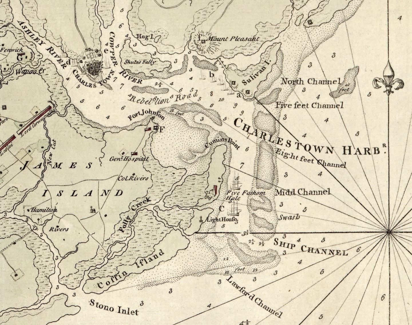
Charleston Harbor is a natural basin formed by the confluence of the rivers Ashley, Cooper, and Wando at the eastern edge of the Atlantic Ocean. The harbor is bounded roughly to the west by the peninsula of Charleston, to the south by James Island, and to the north by the mainland now known as Mount Pleasant. The eastern mouth of the harbor, measuring just over a mile wide, is framed by two barrier islands—Sullivan’s Island to the north, and Morris Island to the south. Viewed as a whole, these several features outline the perimeter of a broad basin of calm, relatively deep water encompassing nearly fifteen square miles. This is an environment well-suited to the reception of ocean-going vessels, where they might anchor safely to load and unload both cargo and passengers. The earliest English settlers who arrived at this location in 1670 recognized the value of these features and planted South Carolina’s first permanent settlement within the commodious waters of Charleston Harbor.

There are no naturally-occurring rocks in this vicinity, but early mariners in the Charleston area recognized a serious obstruction at the mouth of the harbor. Like many other coastal harbors, entry into the Port of Charleston was once complicated by the presence of a sizeable oceanic bar. This bar was not a monolithic structure, but rather a cluster of shallow shoals of sand below the surface of the water, formed by the intersection of opposing forces. Twice a day the flooding ocean tide pushes salt water into the harbor, and twice each day the ebbing tide disgorges fresh water into the ocean. The strong ebbing tide also flushes river sediments out of the harbor, where they collide with ocean currents flowing from the northeast to the southwest. The collision of these forces just beyond Sullivan’s Island causes the suspended sediments to settle on the seabed outside the mouth of the harbor. Over time, the accumulated sediments coalesced into a barrier or bar.
Despite its name, the former bar of Charleston Harbor wasn’t a linear feature, but more like an elongated, lumpy triangle, oriented on a roughly north-south axis, with the bulk of the mass located at its southern end. This triangular obstruction was more than five miles in length, extending southward from the middle of Sullivan’s Island to the southern end of Morris Island. The broader southern end of the bar projected approximately three miles offshore from Morris Island. From that point, the bar tapered back towards the shoreline in a southerly direction, creating a broad and dangerous sandbank in front of Folly Island, which early mariners called “the Coffin Land.”[1]
The bar represented a grounding hazard for all but the smallest vessels sailing in and out of the harbor, but it was traversed by a number of channels of varying size. The number, width, and location of the channels evolved over the years as hurricanes and ocean currents reshaped the shoals below the surface of the water. In the two centuries after the founding of Charleston in 1670, for example, local mariners referred to a relatively-stable “North Channel” and “South Channel,” located near Sullivans’s Island and the southern end of Morris Island, respectively. Between these features, eighteenth-century mariners noted the presence of a “Five-foot Channel,” an “Eight-foot Channel,” a “Middle Channel,” a “Swash Channel,” and, at the extreme southern end near Folly Island, the so-called “Lawford Channel.” Small vessels, like fishing boats, sloops, and coastal schooners could choose one of the several channels into the harbor and pass the bar with little difficulty. Larger vessels, however, were obliged to use the deepest and most stable channel, the so-called “Ship Channel,” later called the “Pumpkin Hill Channel,” located near the southeast end of what was formerly known as Middle-Bay Island (now the southern end of Morris Island).

Ships entering the Port of Charleston today follow a rather straight path from the Atlantic Ocean into the center of the harbor, but mariners of the distant past had to navigate through a serpentine obstacle course to reach the same destination. To find the entrance to the Ship Channel, for example, a vessel approaching the South Carolina coastline first had to triangulate its location with respect to landmarks on the horizon. The starting point for entering the channel was an offshore location approximately three to four miles east-northeast from the southern end of Middle-Bay (Morris) Island, and approximately six to seven miles south-southeast of Sullivan’s Island. Sailing west-by-north, vessels entered the Ship Channel and sailed approximately one mile through a sandy gauntlet.[2]
The depth of the water in the Ship Channel varied between high and low tide, and evolved over the years. Surviving logbooks of the British naval vessels that were stationed in Charleston harbor in the early eighteenth century, for example, record depths between two-and-a-half and three-and-a-half fathoms (fifteen to twenty-one feet) in the Ship Channel.[3] This range of depth was sufficient for large vessels carrying up to approximately 500 tons burden, which was ample for the purposes of eighteenth-century commerce, but it left little room for error within the channel. Even with a favorable tide and an experienced pilot at the helm, the possibility of sudden contrary gusts rendered every crossing a dangerous venture. Accidents were uncommon at Charleston’s bar, but often serious when they occurred. A keel strike against the sandy bottom or a lateral bump against the shoal could cause significant leaks, and wind-swept waves could quickly beat an injured ship to pieces.

Once a vessel passed through the ship channel, it had to make a rather sharp turn to starboard and head north. If the vessel experienced any difficulty or the weather changed, there was an opportunity to pause and anchor within a relatively deep pool at this location called “Five Fathom Hole.” Proceeding northward from the hole for approximately two miles, vessels then turned gradually to port and rounded the head of Coming’s Point, now the northern end of Morris Island, being careful to avoid a shallow bank called the “Middle Ground” on which Fort Sumter now stands. Continuing westward past that brick landmark, vessels entered the body of the harbor.
The deepest point in the harbor—and therefore the safest spot to anchor—has always been a point approximately half-way between the peninsula of Charleston and the bar at the entrance of the harbor called “Rebellion Road.” Located approximately one mile west of the southwest end of Sullivan’s Island, this anchorage or roadstead acquired its provocative name by the year 1692 because it lay beyond the range of cannon that might be fired from East Bay Street to enforce His Majesty’s customs regulations.[4] After anchoring in Rebellion Road, arriving ships frequently sent a rowboat to the Charleston waterfront to negotiate arrangements for docking the vessel at a proper berth next to the town.

Ships exiting Charleston harbor followed in reverse the same serpentine route covering ten to twelve miles. After casting off from a wharf or an anchorage next to the town, they would usually sail two or three miles to Rebellion Road and wait there at anchor for a favorable combination of wind and tide. When the elements aligned, the larger vessels would sail eastward towards the ocean, avoiding the Middle Ground that is now Fort Sumter, then turn to starboard around Coming’s Point and continue on a southward trajectory towards Five-Fathom Hole. After a pause at the hole, if necessary, ships turned hard to port near the southern end of Morris Island and followed the Ship Channel eastward into the Atlantic Ocean.
From the earliest days of the English settlement of South Carolina in the 1670s, vessels traveling into and out of the Port of Charleston have relied on experienced local mariners for guidance through the relatively narrow mouth of the harbor. Specialized knowledge of the bar was vital to the local economy, in Charleston as elsewhere, because the maritime charts and maps available during the late-seventeenth and early-eighteenth centuries contained far less detailed information than modern resources. To enter Charleston Harbor three centuries ago, just as today, it was faster and safer to hire a local pilot, who would climb aboard ship and assume temporary command as they plied through the obstacles to a safe berth.
During the early decades of the Carolina Colony, local mariners acted independently as pilots to guide visiting ships across the bar into Charleston Harbor, but this work became increasing regulated as the colony matured. The earliest surviving legislation to regulate the “pilotage” of Charleston Harbor, dating from the spring of 1691, restricted this service to just three men who were obliged to keep watch along the coastline and assist all ships desiring to enter or exit the harbor. Subsequent revisions to the pilotage law increased the number of pilots and refined their responsibilities and liabilities as ship traffic through the port increased. To aid the flow of commerce in 1711, South Carolina’s provincial government began contracting with private parties to install floating buoys at the bar to mark the location of the principal channels. The most significant navigational development for colonial Charleston occurred in the spring of 1734, when the South Carolina General Assembly established a board of “Commissioners of Pilotage” to regulate the work of local pilots and maintain the floating buoys. These commissioners were also responsible for the construction of Charleston’s first lighthouse, erected on the southern end of Middle Bay Island in 1767–68 to illuminate the entrance to the Ship Channel.
This system of local governance of navigational issues continued to 1777, when it was revised and continued under the aegis of the new state government during the American Revolution. Following the incorporation of the City of Charleston in August 1783, the new City Council inherited the responsibility for managing the Commissioners of Pilotage and all issues related to navigation within Charleston Harbor. That duty was divided in 1789, however, when the new federal government assumed jurisdiction over harbor and coastal navigation in all the states. From 1790 onward, the United States Government was responsible for maintaining the buoys, beacons, lighthouses, and navigational channels in Charleston Harbor, while local pilots and the Commissioners of Pilotage continued to report to the City Council of Charleston.[5]
The pilots, buoys, and lighthouses provided valuable assistance to the early maritime commerce within the Port of Charleston, but their work was always frustrated by the natural topography of the bar. As larger steam-powered vessels began to supplant traditional sailing ships during the second quarter of the nineteenth century, however, the merchants of Charleston began to adjust their thinking about the underwater environment. Because bigger ships required deeper and straighter channels, the natural constraints of the Charleston bar threatened to impede the future growth of the port. In response, those responsible the navigation of Charleston Harbor began to contemplate the use of emerging technology to alter the natural environment.

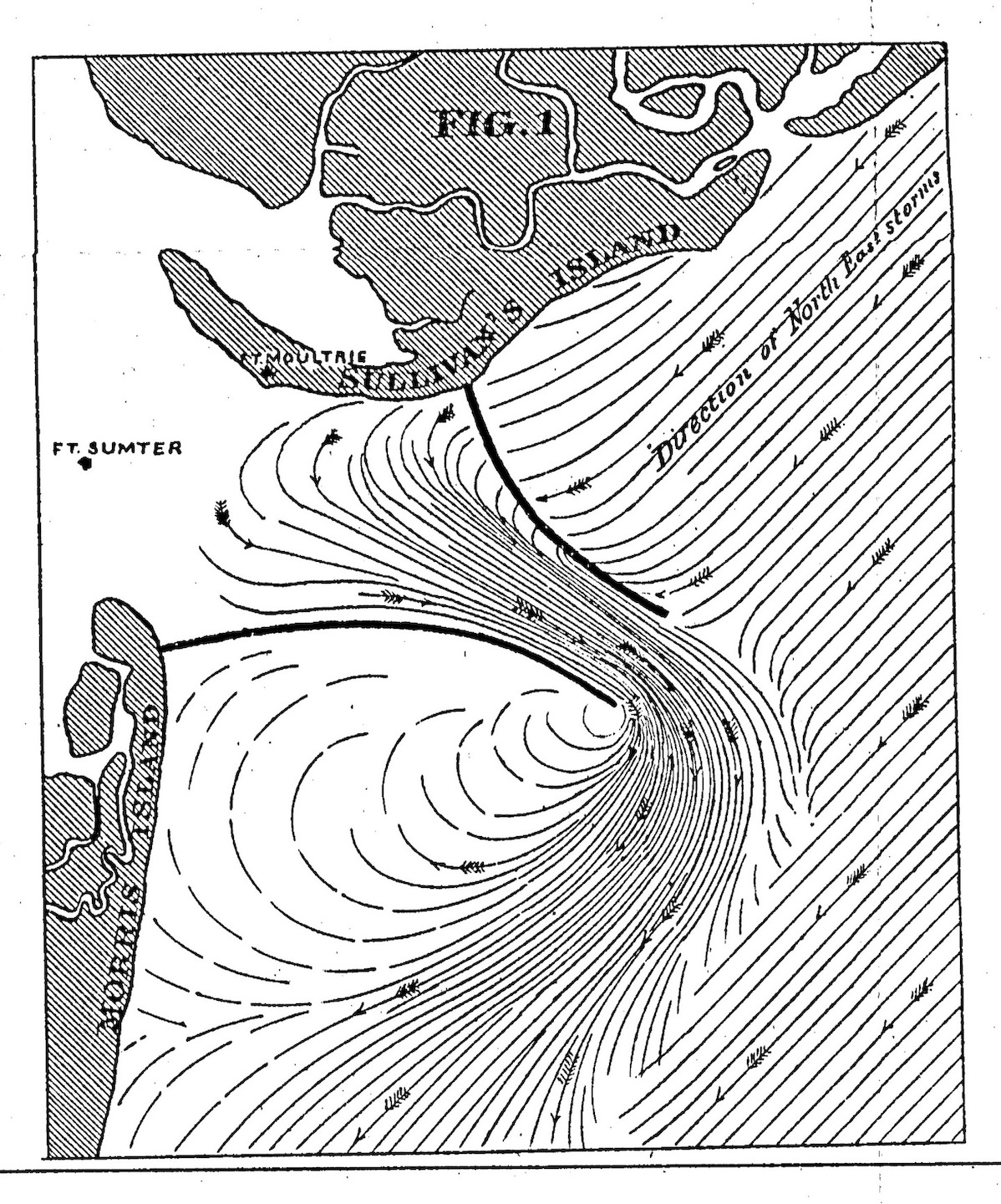
When tidal currents threatened to undermine the walls of Fort Moultrie on Sullivan’s Island in the 1830s, for example, the United States Army Corps of Engineers constructed a stone jetty in 1839 that extended 400 feet eastward from the beach in front of the fort. Bowman’s Jetty, as it became known, created a relatively small disruption in the flow of tidal waters that produced two important results: protective sand accumulated in front of Fort Moultrie, as desired, while the re-directed waters deepened the northernmost channel into the harbor in front of Sullivan’s Island. The improved channel, which became known as “Maffitt’s Channel” or the “Beach Channel” in the early 1850s, quickly became the focus of navigational attention because it offered hope for a more direct route between the ocean and the port. To exploit this possibility, the U.S. Army Corps of Engineers deployed steam-powered dredging machinery to extend Maffitt’s Channel into the heart of the harbor. That project achieved most of its goals, but the outbreak of the American Civil War in 1861 stifled further navigational improvement for a generation.[6]
In the aftermath of the Civil War, Charleston’s maritime commerce struggled to recover its former strength. Besides the great social and economic changes wrought by the war, the mouth of the harbor was littered with the rotting debris of naval defenses and sunken wrecks. Numerous storms had caused the navigational channels to shift positions and grow increasingly shallow. Post-war salvage operations cleared the wrecks, and limited dredging took place in the mid-1870s, but the Port of Charleston required a bold and innovative solution to recapture the former strength of the local maritime economy.
As they had done repeatedly since 1790, Charleston’s civic leaders in the late 1870s turned to the federal government for help with the troublesome bar. The solution came from an ironic source. During the 1870s, the Army Corps of Engineer’s chief engineer for Charleston District was Quincy Adams Gillmore (1825–1888), who, as a general in the Union Army during the Civil War, had supervised the Federal troops attacking and bombarding Charleston a decade earlier. In March 1878, General Gillmore submitted to the Federal government a detailed proposal “for the permanent improvement of the channel of entrance into Charleston Harbor, South Carolina, by means of low jetties.”
Gillmore, a talented engineer, drew from his intimate knowledge of local waterways and from numerous reports compiled by his staff to craft an elegant solution. His 1878 report proposed to build two long, curving lines of stone to frame a new deep-water channel through the bar leading directly into Charleston Harbor. The two jetties resembled a large funnel, the western ends of which were nearly two-and-a-half miles apart, and the eastern ends approximately one-half mile apart. The northern jetty would spring from the beach of Sullivan’s Island, one mile north of Fort Moultrie, and extend eastward nearly three miles into the ocean. The southern jetty would spring from the beach of Morris Island, near the site of Fort Wagner, and extend more than three miles into the Atlantic. Gillmore’s complex engineering calculations predicted that these curving stone structures would restrict and focus the scouring action of the existing currents within a confined area to maintain a depth of at least twenty-one feet at mean low water within the new, artificial channel. He estimated that the project might cost as much as $1.4 million, but, since the work would progress slowly, the necessary funds could be appropriated piecemeal over a number of years.[7]
Federal authorities in Washington approved and funded Gillmore’s proposal in the spring of 1878, and local planning commenced almost immediately. The work of laying broad wooden foundations, called mattresses, under a foundation of stone rip-rap commenced in December 1878, but progressed slowly during the 1880s. Delayed appropriations from Washington rather than technical problems were the main obstacle during the project’s first decade. After Gillmore’s death in 1888, the work continued under the direction of Captain Frederic Vaughan Abbot (1858–1928). In 1889, workers began sinking large granite boulders, quarried from Edgefield, South Carolina, to raise the height of the jetties above the wooden foundations. The eastern or outer ends of the jetties project several feet above the surface of the water, but the inner or western ends do not project above the surface, allowing water, fish, sediment, and small vessels to pass over them without disruption. The last stones were dropped in place during the summer of 1895, by which time local mariners could already discern radical changes to the underwater landscape. The new channel between the completed jetties delivered the depth of twenty-one feet predicted by General Gillmore, and a depth of more than twenty-four feet was measured in summer of 1897.[8]
At the close of the nineteenth century, Charleston’s business community praised the completed jetties as a marvel of engineering that had rescued the Port of Charleston from commercial oblivion. Quincy Gillmore’s design was elegantly simple, but the effort to bring it to fruition was herculean in scope. The project to eradicate Charleston’s troublesome natural bar—by means of an artificial channel—employed hundreds of workers, consumed more than fifteen years of labor, cost just over $4 million, and stacked more than 1.1 million tons of granite rocks into a pair of arching lines that are visible in satellite photographs of the harbor. As a result this work, wrote the Charleston Evening Post in 1898, “every obstacle to the commercial progress of the city has been removed.”[9]

While most citizens might agree that the construction of the stone jetties was a positive step for the community, many lament that the altered flow of sediments across the mouth of the harbor resulted in the gradual erosion of Morris Island.[10] On the other hand, few mariners have expressed any regret over the disappearance of the dangerous “Coffin Land” shoal in front of Folly Beach. Nostalgia for the troublesome old bar of colonial times, with its numerous shifting channels and irregular depths, has been entirely absent. Twenty-first-century pilots continue to guide ships in and out of the harbor on a daily basis, but their sea route is far less treacherous that of their distant predecessors.
The jetties of the late nineteenth century were designed as a permanent improvement to harbor traffic, and their enduring utility is a testament to the industry of the engineers and laborers involved. Dredging between the jetties and into the harbor has continued over the years, however, to ensure that the port can continue to accommodate the ever-increasing size of cargo vessels. As Charleston faces new challenges with the Atlantic Ocean in the coming years, we can draw strength from reflecting on the past. Negotiating the threshold between the sea and the land is an old Charleston tradition.
[1] Every mariner who plied in an out of Charleston Harbor before the era of the modern stone jetties was familiar with the dangers of “the Coffin Land”; the name appears in the logbooks of all the Royal Navy officers stationed here from the 1720s to the 1770s, and appears on most of the maps of this area published during the eighteenth century. A news item in South Carolina Gazette and Country Journal, 4 November 1766, page 3, for example, tells of a ship being “cast away on the Coffin-Land reef, to the southward of our bar, in a hard gale of wind, and went to pieces in four hours.”
[2] The bearings cited here are certainly not as precise as those described in various primary sources from the eighteenth and nineteenth centuries, and are intended for the purpose of illustration only.
[3] See, for example, the captain’s logs of HMS Flamborough (ADM 51/357), HMS Blandford (ADM 51/4126), HMS Scarborough (51/865), HMS Garland (ADM 51/384), and HMS Squirrel (ADM 51/4353) at the National Archive of the United Kingdom.
[4] The phrase “Rebellion Road” was in use by the spring of 1692. The extant journal of the Grand Council of South Carolina from that season contains numerous references to Rebellion Road; see A. S. Salley Jr., ed., Journal of the Grand Council of South Carolina, April 11, 1692–September 26, 1692 (Columbia: The State Company for the Historical Commission of South Carolina, 1907), 5, 8, 9, 14, 16, 18. An anonymous pamphlet published in 1724 confirms that the name arose “from its being below and out of the command of the guns of the forts”; see An Apology or Vindication of F. Nicholson, His Majesty’s Governor of South Carolina, From the Unjust Aspersions Cast On Him By Some of the Members of the Bahama Company (London: T. Payne, 1724), 12.
[5] The documentary evidence related to pilotage in Charleston Harbor stretches back to the beginning of the colony. I plan to expand these two paragraphs in a larger essay in a future program.
[6] For an excellent overview of the work conducted between the 1830s and the 1850s, see John B. Bonds, “Opening the Bar: First Dredging at Charleston, 1853–1859,” South Carolina Historical Magazine 98 (July 1997): 230–50.
[7] See the report of Lt. Col. Q. A. Gillmore, Army Corps of Engineers, 9 March 1878, in Annual Report of the Chief of Engineers to the Secretary of War for the Year 1878 (Washington, D.C.: Government Printing Office, 1878), 554–72. Note that the finished length of the jetties was extended during the course of the work beyond the dimensions specified in Gillmore’s original plan.
[8] Gillmore and Abbot submitted annual reports of their progress to the Chief of Engineers in Washington D.C., which reports are available through the U.S. Army Corps of Engineers Digital Library. In addition, Captain Abbot published useful summary reports in Charleston News and Courier, 15 September 1896, page 1, “Deep Water on the Bar”; News and Courier, 11 September 1897, pages 3–4, “Deep Water on the Bar”; and Charleston Evening Post, 11 June 1898, page 8, “Deep Water on the Bar.”
[9] For the total weight of the stone, see Charleston News and Courier, 15 September 1896, page 1, “Deep Water on the Bar. A Comprehensive Statement by Capt. Frederic V. Abbot, of the government Work in Charleston Harbor”; for the total cost, see Charleston Evening Post, 11 June 1898, page 8, “Deep Water on the Bar. Every Obstacle to the Commercial Progress of the City Has Been Removed. History of the Great Engineering Feat. Men Whom Charleston Will Ever Remember. Ships can Come and Go at All Times. A comprehensive Statement written by Capt. Frederic V. Abbot of the government work in Charleston Harbor.”
[10] For an illustrated account of the changes to Morris Island over the past century, see Douglas W. Bostick, The Morris Island Lighthouse: Charleston’s Maritime Beacon (Charleston, S.C.: History Press, 2008).
NEXT: The Charleston Tar-and-Feathers Incident of 1775
PREVIOUSLY: Brewing Beer for the Carolina Station during the Era of Captain George Anson
See more from Charleston Time Machine
- Log in to post comments
